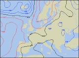
Long-range Outlook: 28/07/04 - 02/08/04
A mixed week ahead, with some settled periods.
Click here for details of the weather over the next few days.
Please note that forecasting beyond five days is notoriously difficult, and small errors at short-range can lead to large deviations further in time. Our longer-range forecasts are based on the most accurate weather data available at the time, but alterations may be required as the period progresses. Please check back regularly for the most up-to-date forecast run.
Wednesday 28/07/04 to Thursday 29/07/04
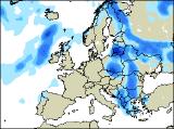
Our previous long-range forecast was hinting at a much warmer, settled spell of weather this week. However, it now looks that by Wednesday, only southern and eastern parts of England will benefit from the warmer air, with some decent spells of sunshine. Low pressure will be in close proximity to western parts, giving a good deal of cloud. In fact, showery bursts of rain will develop during the afternoon across much of Ireland, together with western Scotland and north-west England. By Thursday, the fine weather will be hanging on for dear life across south-east England, as a series of weather fronts sweep in from the west. These will translate into cloudy skies and outbreaks of rain for much of Ireland, Scotland, northern England and Wales, heavy at times. Remaining parts of England will also be at risk from rain in the afternoon. One consolation will be a light wind everywhere, meaning it will still feel fairly warm.
 Friday 30/07/04 Saturday 31/07/04
Low pressure will never be too far away on Friday, and with a weak weather front straddling central parts of the country, there will always be a good deal of cloud around. For Wales, the Midlands and northern England, showery bursts of rain will become heavier during the afternoon. Scotland will also see a few sharp showers developing after a mostly dry start. However, away from these areas, across eastern England and much of Ireland, it should stay dry with some sunny spells. On Saturday, it currently looks as if a very slack area of low pressure will dominate the UK's weather. This will therefore mean that many places will have some warm spells of sunshine, but equally others will have a few heavy downpours. These are most likely across central parts of England, together with northern England and Scotland, and as they will be slow moving some lengthy downpours are possible. Ireland and Northern Ireland will have the best of the sunshine, with fewer showers here.
 Sunday 01/08/04 Monday 02/08/04
Just as one area of low pressure pulls away to the east on Sunday, another, deeper area of low pressure will move in from the west. This will bring outbreaks of heavy rain to much of Ireland, Northern Ireland and western Scotland during the day, along with a strengthening south-westerly wind. After a mostly dry start across England and Wales, afternoon sunny spells will spark off heavy showers, especially towards the east coast. Feeling warm in the south and east, but cooler elsewhere. Monday will remain very unsettled, as weather fronts race across the country from the west. Some of the rain associated with these will be heavy and thundery, and it may turn rather muggy in the east for a time. Fresher weather with westerly winds will reach all parts by evening though. Please check back for further forecast updates.