Long-range Outlook: 28/08/04 - 02/09/04
Mostly unsettled, but the hint of sunshine in the south next week.
Click here for details of the weather over the next few days.
Please note that forecasting beyond five days is notoriously difficult, and small errors at short-range can lead to large deviations further in time. Our longer-range forecasts are based on the most accurate weather data available at the time, but alterations may be required as the period progresses. Please check back regularly for the most up-to-date forecast run.
Saturday 28/08/04 to Sunday 29/08/04
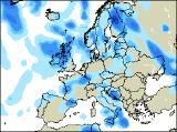
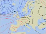
The unsettled weather is set to continue across the UK over the weekend, although Saturday should see a window of drier weather. The best of any sunny spells will be across Scotland, northern England and north Wales, and with light winds it will feel quite pleasant. However, across southern parts of England and Wales, together with Ireland, there will be more cloud around with the risk of showery rain. Further wind and rain will also reach northern Ireland during the afternoon. By Sunday, yet another deep area of low pressure will race into north-western parts of the UK. This will bring strong to gale force westerly winds across western Scotland and Northern Ireland, together with plenty of cloud and heavy rain. The wet weather will also affect much of Ireland, together with northern England and north Wales. Remaining parts of the UK will be mostly dry, but will become increasingly cloudy with rain arriving by evening.
 Monday 30/08/04 Tuesday 31/08/04
The start of the new week will bring no joy for the return of the UK summer, as low pressure remains in the North Sea, and very much in control of our weather. Fresh to strong north-westerly winds will make it feel rather cool everywhere, and may again touch gale force in parts of Scotland. Cloudy skies with outbreaks of rain will affect much of eastern England, together with Scotland. Elsewhere, some sunshine will develop, but with a scattering of heavy and possibly thundery showers. However, Tuesday does bring some hope for summer, especially across much of England and Wales, along with southern parts of Ireland. Here, a weak ridge of high pressure will give largely dry conditions, with some warm spells of sunshine. The same can't be said for parts of northern England, Northern Ireland and Scotland however. Here, cloudy skies will provail, with further bursts of showery rain. At least the winds will ease everywhere.
 Wednesday 01/09/04 Thursday 02/09/04
To many, the start of September signals the end to the UK summer, and the start of Autumn. For Scotland, Ireland and northern England, this will indeed be the case, as strong westerly winds give a good deal of rain-bearing cloud across most parts on Wednesday. However, in stark contrast, what is left of the UK summer will be doing its best to hang on across the rest of England and Wales, with some warm spells of sunshine throughout the day. At the moment at least, this twist in the current weather pattern looks like holding into Tuesday, with high pressure giving England and Wales another fine, sunny day. However, weather fronts will be straddled across remaining parts of the country, giving rain at times. Perhaps the far north of Scotland will become brighter during the afternoon. The outlook beyond this is currently very interesting, and is suggesting that much warmer, settled conditions will affect much of the UK. However, please check back for further forecast updates.