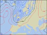
Long-range Outlook: 27/09/05 - 02/10/05
Low Pressure Dominating!
Click here for details of the weather over the next few days.
Please note that forecasting beyond five days is notoriously difficult, and small errors at short-range can lead to large deviations further in time. Our longer-range forecasts are based on the most accurate weather data available at the time, but alterations may be required as the period progresses. Please check back regularly for the most up-to-date forecast run.
Tuesday 27/09/05 to Wednesday 28/09/05
We're still expecting a potentially stormy Tuesday in northern parts of the UK, as a deep area of low pressures passes to the north of Scotland. Gale to severe gale force westerly winds will affect northern and western Scotland, with gales too across the coasts of Northern Ireland. However, it will be very windy across the whole of the UK and Ireland, with spells of heavy rain sweeping east in the morning. This rain will clear from eastern England in the afternoon, leaving sunshine and blustery showers everywhere. The heaviest, and most frequent showers will be in the northwest. After a calmer start to Wednesday, another small low will race across Northern Ireland and northern England in the afternoon. On the south side of this low, winds will become strong, with a risk of gales across Northern Ireland, northern England and north Wales. As well as the wind, heavy and persistent rain will affect these areas, including much of Scotland too. To the south of this, across southern Ireland, southern England and south Wales, it will be drier but rather cloudy.
 Thursday 29/09/05 to Friday 30/09/05
Wednesday's rain will spread south on Thursday morning, becoming slow-moving across south Wales, southern England and southern parts of Ireland. Some of this rain will be heavy, and is expected to last for much of the day. In fact, another small low moving in from the south-west later will intensify this rain during the evening. Further north, across the rest of England and Wales, there will be some sunny spells, but on the whole it will be cloudy. Scotland and Northern Ireland will hold on to a mixture of sunny spells and showers. The moderate southwesterly wind will be less of a feature of Thursday's weather. Confidence for Friday's forecast is currently rather low, due to the position and intensity of low pressure to the north of Scotland. However, current indications suggest that strong southwesterly winds will veer sharply northwest during the day, behind a very active cold front. The rain associated with this cold front will be heavy as it sweeps east across the country, with potentially squally conditions on its back edge. There could even be hail and thunder in places.
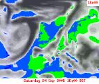 Saturday 01/10/05 to Sunday 02/10/05
We're looking to a potential pattern change on Saturday, as our train of depressions finally give way to high pressure building in from the south-west. North to northwesterly winds will be strong during the morning, possibly with gales on eastern coasts. There will also be plenty of showers here. The rest of England, Wales and Ireland will become dry with some sunny spells through the day. However, there is the chance that more cloud and rain will spread across Scotland and Northern Ireland in the evening. Sunday should stay dry with some sunny spells in England and Wales, although there are uncertainties as to whether high pressure will hang on through the afternoon. Elsewhere, fresh westerly winds will blow in a lot of cloud and outbreaks of rain. For more details on next weekend and beyond, please check back for further forecast updates.