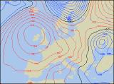
Long-range Outlook: 28/01/05 - 02/02/05
High pressure in control. Settled throughout.
Click here for details of the weather over the next few days.
Please note that forecasting beyond five days is notoriously difficult, and small errors at short-range can lead to large deviations further in time. Our longer-range forecasts are based on the most accurate weather data available at the time, but alterations may be required as the period progresses. Please check back regularly for the most up-to-date forecast run.
Friday 28/01/05 to Saturday 29/01/05
The weather will be settled during Friday, but this does not mean there'll be much sunshine around. With high pressure out to the west, the UK and Ireland will be in an Atlantic airmass, with mild air toppling around the northern edge of the high, and returning southwards. The best of any sunshine will be across Ireland and Northern Ireland, closest to the high's centre. Across England, Wales and Scotland, there will be a lot of cloud around. Eastern England will also have occasional rain and drizzle. Chilly in the south, but milder further north. The synoptic setup will bring virtually no change on Saturday, with our controlling high hardly moving an inch. Therefore, it will be a very similar day, with some sunny spells, the best of which will be in western areas once again. However, the cloud across England and Wales should break somewhat, and patchy drizzle in the east and south will become increasingly isolated. A little milder in the south too.
 Sunday 30/01/05 to Monday 31/01/05
During Sunday, there will be some subtle changes, in that the area of high pressure will drift ever closer to the UK and Ireland. It could be a foggy start with light winds across Ireland and Northern Ireland, but this will soon clear to leave a sunny afternoon. There will also be some sunshine across England and Wales, but eastern areas will be rather cloudy. Scotland will have an early frost, but apart from some patchy cloud in the north and east, it will stay dry and bright. It will be another misty and in places, frosty night, but Monday will start off dry with some sunshine otherwise. Once again, beneath the area of high pressure, western Scotland, Northern Ireland and the Irish Republic will have the best of the sunshine. There could be slightly more in the way of cloud across England, Wales and eastern Scotland, thickest once again in the east where it could give drizzle. However, there will be some brightness around.
 Tuesday 01/02/05 to Wednesday 02/02/05
The start of February will bring only very slight changes, with the high pressure remaining directly over the UK on Tuesday. The thicker cloud and drizzle should pull away from eastern England, allowing more in the way of brightness. The rest of England, Wales and eastern Ireland will also have sunshine. However, as winds turn south-westerly across western Ireland and western Scotland, thicker cloud and milder air will threaten patchy rain later in the day. Wednesday looks like being the change to finally break our blocking area of high pressure. A cold front is expected to sweep in from the west during the day, turning winds westerly behind a spell of heavy rain. However, confidence on the timing of this change is very uncertain at present, so please check back for further forecast updates.