The Week Ahead
Gales and a cold spell
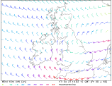
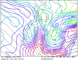
 Forecast valid for Sunday 27/10/02 to Saturday 02/11/02 TOI Friday 25/10/02 0900 BST. Based on GFM, UKMO, and ENS labelled model.
After a wet and very windy weekend conditions will turn drier, but also colder for much of the following days. All places away from the coasts will have seen some overnight frost by mid-week. There is small chance for a spell of mild warmth towards the end of the week, but with a risk for patchy light rain as well.
Sunday. A day well below 10C for N Ireland and all parts north of the Midlands. Turning much milder towards the south. A deep low will sweep across the British Isles entering Ireland early on Sunday and northern England some hours later. Rains will be heavy for a time and conditions will turn very stormy. S Ireland, Wales and S and SW England will get the strongest, gale force winds. Less strong winds, but still breezy with more general rain for the northern half of the UK. Winds will ease later to leave a bright and breezy afternoon, with scattered, but chilly, showers turning wintry in the Highlands.
 Confidence is good (70%) that Monday will see the low moving away from the eastern British Isles to leave a cold, bright day with sunny periods and few scattered showers for S Ireland, England and Wales. A few more showers, wintry on higher grounds, for N Ireland and Scotland with sunny spells as well. Nights will turn cold and clear with air and ground frost inland.
 Tuesday to Thursday . Confidence is moderate that another batch of rain will hit the southwest and south. on Tuesday. Otherwise mostly dry, but cold with early frost and fog patches for much of the British Isles. Coastal showers likely across the northwest. Wednesday will see a mainly dry, bright, but chilly day for most, while there is a low confidence chance for milder air pushing in from southwest on Thursday.
At the end of the week a renewed southwesterly warm front might bring milder temperatures, but also more clouds and some rain or drizzle.