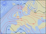
Long-range Outlook: 30/01/06 - 04/02/06
High Pressure Running The Show!
Click here for details of the weather over the next few days.
Please note that forecasting beyond five days is notoriously difficult, and small errors at short-range can lead to large deviations further in time. Our longer-range forecasts are based on the most accurate weather data available at the time, but alterations may be required as the period progresses. Please check back regularly for the most up-to-date forecast run.
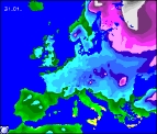
Monday 30/01/06 to Tuesday 31/01/06
After high pressure has dominated most of this week's weather, it may come as no surprise that the huge anticyclone looks like hanging around into Monday of next week. Centred slap-bang over the northern England, the UK and Ireland will have another dry day with sunny spells. There will be a widespread frost first thing, but as a result, there will be some sunshine during the day. However, large amounts of cloud will also float around, particularly across southern England, where there will be a keen easterly wind. It will be a case of 'spot the difference' on Tuesday, as the high pressure remains in place. After a frosty start, perhaps with a few freezing fog patches, it will be dry everywhere once again with sunny spells. It will be very difficult to pin-point where the best of the sunshine will be, as areas of low cloud will still tend to come and go. A freshening southerly wind will blow in more cloud across western parts of Ireland during the afternoon.
 Wednesday 01/02/06 to Thursday 02/02/06
Forecasting where high pressure will move is often very difficult, so even by Wednesday, confidence is rather low as to exact weather detail. However, it does look likely that our resident high will gradually decline eastwards into the North Sea. It will be closeby though, so most of the UK and Ireland will still have a sunny day, once morning fog and frost has cleared. The exception will be northern Scotland and the far west of Ireland, as weak fronts deliver more cloud, and a risk of patchy rain. Milder conditions will accompany this cloud, as will fresh winds. The decline of our high will be a very slow process, so it will still be influencing much of our weather into Thursday. After a morning frost, England and Wales will remain dry with variable cloud and some sunshine. Across Scotland, Ireland and Northern Ireland, skies will be predominantly cloudy, although any drizzle will be restricted to west-facing, windward coasts. Staying chilly in the east of the UK, but milder out to the west.
 Friday 03/02/06 to Saturday 04/02/06
On Friday, it looks set that high pressure will finally edge away eastwards, allowing mobile westerly winds to flow in off the Atlantic. These winds will blow in a good deal of cloud and outbreaks of rain, firstly to Ireland, Northern Ireland and southwest England, reaching Wales and northwest England later. Remaining parts of England, Wales and Scotland will be dry but mostly cloudy. It's anyone's guess what will happen next weekend, as model disagreement provides little clues. There is every chance that high pressure could return from the north, settling the weather across all but Ireland and south-western parts of England. Other outputs suggest that low pressure will deepen and move in, bringing with it outbreaks of rain for many areas. Our suggestion, is to check back for further long-range forecast updates, when confidence of next weekend's weather will be greater.