Long-range Outlook: 01/03/05 - 06/03/05
Cold at first. Gradually turning milder.
Click here for details of the weather over the next few days.
Please note that forecasting beyond five days is notoriously difficult, and small errors at short-range can lead to large deviations further in time. Our longer-range forecasts are based on the most accurate weather data available at the time, but alterations may be required as the period progresses. Please check back regularly for the most up-to-date forecast run.
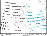
Tuesday 01/03/05 to Wednesday 02/03/05
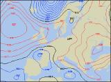
The recent cold spell was looking like coming to an end this weekend, and to a certain extent, it has. However, all indications are now pointing at the return of cold weather next week, and Tuesday will be no exception. Models suggest that an area of low pressure will be positioned in the North Sea, dragging in cold east to south-easterly winds once again. Outbreaks of rain and sleet are expected to spread southwards across the country, followed quickly by more persistent snow. Over the high ground in northern England, several centimetres are possible, but even on lower ground across England and Wales, accumulations are likely. For western Scotland, Ireland and Northern Ireland, Tuesday should be mainly dry with some brightness. The low will remain in place on Wednesday, thus maintaining a cold easterly wind. Frequent sleet and snow showers will affect England and Wales, always heaviest in the east where a covering is likely. Changes will occur across Northern Ireland and Scotland, as winds become westerly. Rain will spread eastwards here, with sleet and snow falling for a time.
 Thursday 03/03/05 toFriday 04/03/05
Conditions are expected to become somewhat milder during the course of Thursday, as high pressure topples in from the west. This will be a very slow process though, and southern parts of England are likely to remain cold with scattered snow showers for much of the day. The rest of England Wales will be rather cloudy with patchy light rain or sleet. However, after a cloudy start, Ireland and Northern Ireland will become drier, brighter and milder. Scotland should also see some brightness after a damp morning. On Friday, high pressure is expected to be firmly anchored to the north of the UK, drawing in milder, returned Atlantic air from the north-west. These setups will always drag in a lot of cloud across Northern Ireland and Scotland, and with it will come occasional light rain and drizzle. The rest of the UK can also expect to see a lot of cloud, but particularly in sheltered eastern and southern areas, there will be some sunshine as well. Perhaps the best of the sunshine will be across southern parts of Ireland where it will feel fairly pleasant in light winds.
 Saturday 05/03/05 to Sunday 06/03/05
There will be little change during Saturday, as high pressure to the west continues to throw north-westerly winds right across the UK and Ireland. Once again, drizzle and low cloud will plague western Scotland and Northern Ireland, but sheltered eastern areas will have some brightness. England and Wales will have a better chance of seeing sunshine today, although patchy drizzle may affect the east coast at times. Temperatures around average for the time of year, perhaps above in the sunshine further south. Staying mostly dry and bright across many areas during Sunday, as the synotpic setup remains the same. However, across the north thickening cloud is expected to bring more prolonged spells of light to moderate rain southwards during the day, but despite this it will still feel a good deal milder than recently. For more details on the weather for next weekend, please check back for further forecast updates.