Long-range Outlook: 29/10/05 - 03/11/05
Very Mild. Rain Or Showers.
Click here for details of the weather over the next few days.
Please note that forecasting beyond five days is notoriously difficult, and small errors at short-range can lead to large deviations further in time. Our longer-range forecasts are based on the most accurate weather data available at the time, but alterations may be required as the period progresses. Please check back regularly for the most up-to-date forecast run.
Saturday 29/10/05 to Sunday 30/10/05
Southerly winds will continue across the UK on Saturday, but it won't be quite as warm as recently. Spells of showery rain will clear from Southeast England and East Anglia during the morning, leaving most of England and Wales dry with occasional sunny spells. However, an active cold front will spread heavier rain across Ireland and Northern Ireland during the morning, reaching most of Scotland, West Wales and Southwest England by evening. A risk of southerly gales through the Irish Sea and around the coasts of Ireland. A large area of low pressure will remain to the west of Scotland on Sunday, maintaining a south to southwesterly airflow. Rain will continue for much of the day across England and Eastern Scotland, but morning rain across Wales, and Western Scotland will clear to showers and occasional sunny spells. Showers will also affect Ireland and Northern Ireland, but during the afternoon, thicker cloud will spread more persistent rain back across western areas. Feeling cooler still, although the chance of gales in the Irish Sea will subside.
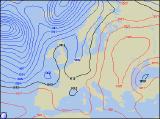 Monday 31/10/05 to Tuesday 01/11/05
Hallowe'en was originally looking unsettled with rain, although latest model runs are now indicating that a small ridge of high pressure may give more settled conditions for those of you out 'trick or treating'! Heavy rain across central and Eastern England during the morning should clear by early afternoon, although it could linger across Kent into the evening. A few showers are also likely across Western Scotland and Northern Ireland throughout the day. Elsewhere, it will be a dry day with increasing amounts of sunshine, and as it remains dry into the evening, a few mist and fog patches could develop, adding to the spooky Hallowe'en atmosphere! On Tuesday, after a chilly start with fog patches, high pressure will dominate the weather across most of England, Wales and Scotland, with some sunshine developing. However, western areas will cloud over during the afternoon. A very different day across Ireland, as a weather front produces cloud and outbreaks of rain throughout the day. Southerly winds will become fresh here once again.
 Wednesday 02/11/05 to Thursday 03/11/05
High pressure will begin to lose its grip on Wednesday, with any dry and sunny weather restricted to Southeast England. Elsewhere, there will be a good deal of cloud, and showery rain will spread slowly west across the rest of England and Wales during the day. After a brief drier interlude, an active cold front will spread more rain across all of Ireland through the afternoon, reaching Western Scotland before evening. Fresh southerly winds will make it feel very mild once more. The mild but unsettled conditions will persist through Thursday, with the said cold front moving slowly from west to east, giving heavy rain in most places. Through the afternoon, the rain will clear in northern and western areas, leaving colder conditions with a scattering of showers. There is still no sign of winter on the horizon! For more details on next week's weather, please check back for further forecast updates.