Long-range Outlook: 31/05/05 - 05/06/05
Some sunshine, but generally unsettled.
Click here for details of the weather over the next few days.
Please note that forecasting beyond five days is notoriously difficult, and small errors at short-range can lead to large deviations further in time. Our longer-range forecasts are based on the most accurate weather data available at the time, but alterations may be required as the period progresses. Please check back regularly for the most up-to-date forecast run.
Tuesday 31/05/05 to Wednesday 01/06/05
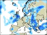
Tuesday will be a very mixed day country-wide, as weather fronts affect southern and western areas. Most of Ireland will have a wet day, with outbreaks of persistent rain. This rain will extend into parts of south Wales and south-west England, with showers breaking out through the Midlands and the rest of southern England. Although there will be a lot of cloud, northern England and Northern Ireland should get away with a dry day, although the best of the sunshine will be reserved for Scotland. Temperatures above average, although rather cool in the rain. The dry and bright weather should just about hold on across Scotland on Wednesday, but low pressure moving in from the west will spread rain across many other areas. In fact, the rain across Northern Ireland, northern England and parts of Wales could be particularly heavy during the afternoon, as it spreads slowly to the rest of England. The best bet for any drier weather will be in the south-east, where the rain will be lighter. Southern coastal areas of Ireland could also escape with a dry afternoon once the morning rain clears.
 Thursday 02/06/05 to Friday 03/06/05
Low pressure will remain in control during Thursday, translating into rain or showers for everyone. Even Scotland will be cloudier with rain at times, always heaviest over western hills and mountains. The rain will also intensify across Ireland and Northern Ireland during the afternoon, after a relatively dry start. Across England and Wales, the rain will be more sporadic than of late. In fact, some brighter spells should develop between showers in the afternoon, although the showers will be heavy, perhaps with thunder. Warm in any brightness, as winds remain light. Signs of a temporary change are looking more and more likely for Friday, as a small ridge of high pressure drifts in from the west. Bright or sunny spells are likely to increase as the day progresses across western Scotland and much of Ireland. Further east across eastern Scotland and northern England, there will be some rain around at first, but this should die away to leave cloudy conditions. Remaining parts of England and Wales will have one or two showers, but these will become isolated later with brightness increasing.
 Saturday 04/06/05 to Sunday 05/06/05
Preliminary indications for Saturday suggest that it won't be a bad day for much of England, Wales and Scotland. There will be a lot of cloud around, perhaps with an isolated afternoon shower, but otherwise it will be dry with some sunshine. It'll be a different story for Ireland and Northern Ireland though, as morning brightness gives way to cloud and rain moving in from the west later. Becoming windy in the west later too. Sunday is looking very interesting. Could this be the start of a heat wave for England and Wales? Well, confidence is currently low at such range, but models do indicate that low pressure to the west will begin to pump warm air up from the south, affecting southern England later on Sunday. However, the downside of these situations results in heavy rain across Ireland, Northern Ireland, and later western parts of Scotland. Early indications for the start of the following week really warm things up across England and Wales. However, please check back for more details in further forecast updates.