Weekly Outlook : 28/03/03-03/04/03
Briefly Unsettled, then Fine & Dry South, Cloudy/Damp NW.
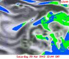 Friday 28/03/03 to Sunday 30/03/03
Another bright, sunny day across central and eastern parts once morning mist and fog clears. Becoming warm again here, although cooler around the coasts. Across the south-west and Ireland however, fronts will spread cloud and occasional rain in from the south-west, possibly into southern England in the afternoon. At the same time, cloud and patchy rain will spread into north-west Scotland. The rain will begin to push south-east overnight and into Saturday, although becoming very light and patchy. By the end of Saturday, only the far south will see the cloud, elsewhere turning sunny once more. By Sunday, all parts will once again see high pressure dominating, with long sunny spells. The exception will be the far north-west, with more cloud around here and the odd spot of rain. Mild everywhere.
 Monday 31/03/03 to Tuesday 01/04/03
The weather across the UK will depend on the subtle changes in position of our resident high pressure, so confidence is fairly low at this stage. However, it does look as if most of England and Wales will stay fine, with long spells of sunshine after morning frost and fog clears. It will be mild with temperatures increasing during this period. Westerly winds look set to increase across the north and north-west, as low pressure systems spread fronts in from the west. There will be a good deal of cloud and some rain, especially during Tuesday. Cooler here also.
 Wednesday 02/04/03 to Thursday 03/04/03
High pressure hanging on in the south of England and Wales, giving further sunny spells after overnight murk proves slow to clear. A weak front is expected to cross into central parts bringing an increase in cloud. Further spells of light rain or showers are expected across Northern Ireland and Scotland, perhaps becoming heavier by Thursday afternoon. Still very mild or warm in the south, around average in a breezier north.