Weekly Outlook : 29/09/03-05/10/03
Unsettled With Rain. Substantial Rainfall In South At Last!
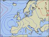 Monday 29/09/03 to Tuesday 30/09/03
A chilly start across England and Wales, with a touch of frost in places. The bonus being a dry day with plenty of sunshine, especially across central and southern England with highs nearing 20 degrees Celsius. A different story for much of Scotland, Ireland and Northern Ireland however, as weather fronts bring a good deal of cloud. There will be outbreaks of rain at times, spreading eastwards to reach North Wales and Northern England by evening. Cooler in the north later, especially after dark as skies begin to clear. Tuesday will dawn cloudy across north Wales, northern England and parts of Ireland, still with some showery rain at times. To the south and east, a largely dry and bright day, becoming quite warm. For Scotland and Northern Ireland, it will be dry with bright spells, but feeling rather cool. During the evening, south-easterly winds will freshen across southern England, heralding a change.
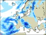 Wednesday 01/10/03 to Thursday 02/10/03
An unsettled morning across southern England and south Wales, with overcast skies and spells of rain, some heavy. Parts of Northern England and southern Scotland will also be cloudy, with the remnants of Tuesday's fronts still sitting across the regions. Rain will persist across southern Britain for much of the afternoon, still the odd heavy burst. There will be bright spells across northern England at times, and also in the far north of Scotland and Northern Ireland. Little change by Thursday, with largely cloudy skies across central and southern England, along with Wales. Showery bursts of rain will also continue here, with heavy showers following to southern coasts later. A brief drier interlude across parts of northern England and Ireland, with brighter spells. For Northern Ireland and Scotland however, skies still largely cloudy with further bursts of rain from time to time.
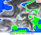 Friday 03/10/03 to Sunday 05/10/03
The detail for the coming weekend is currently rather uncertain, and depends on the progress of low pressure to the south of the UK. However, it does look at present that low pressure will track to the east of the UK, allowing a feed of cold north to north-westerly winds across many parts. Rain will be slow to clear from eastern counties during Friday and early Saturday, but already northerly winds will allow conditions to brighten across western parts of the UK and Ireland. There will be some showers around however, especially during Saturday and Sunday in western parts. The extreme south of England is expected to cloud over again during Saturday night, with outbreaks of rain at times during Sunday. More detail on the latter part of the weekend in Wednesday's update.