Long-range Outlook: 02/07/05 - 07/07/05
Low pressure in control. Rain for many.
Click here for details of the weather over the next few days.
Please note that forecasting beyond five days is notoriously difficult, and small errors at short-range can lead to large deviations further in time. Our longer-range forecasts are based on the most accurate weather data available at the time, but alterations may be required as the period progresses. Please check back regularly for the most up-to-date forecast run.
Saturday 02/07/05 to Sunday 03/07/05
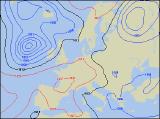
Saturday's syoptic setup would look more at home on an Autumnal weather chart, as an unusually deep depression gathers strength to the west of Scotland. This will result in strong south to south-westerly winds across Ireland, Northern Ireland and western Scotland, with a risk of coastal gales. Weather fronts will spread rain across Ireland during the day, although amounts in the south-east will be small. This rain will move into western Scotland and north-west England during the afternoon, heavy over the hills. After a bright morning, cloud will thicken across Wales, the Midlands, south-west England and eastern Scotland, perhaps with orographic rain over the hills later. The driest, sunniest conditions will be reserved for eastern and south-eastern England. On Sunday, the low pressure will continue spinning strong south-westerly winds across the UK and Ireland, with coastal gales in the north-west. Many places will be cloudy, although most of the rain will still be in northern and western areas. Perhaps some brightness to the east of high ground across north-east England and east Wales.
 Monday 04/07/05 to Tuesday 05/07/05
For a time on Monday morning, rain may become heavy across eastern parts of England, with thunder in places. However, it will clear east to leave much of central and eastern England a mixture of sunny spells and scattered showers. After an initially dry morning, heavier and more frequent showers will affect Wales and western England, blown in on cool westerly winds. Ireland, Northern Ireland and Scotland will suffer more prolonged rain in the afternoon, and as a result it will feel a good deal cooler than recently. Low pressure will continue to dominate the UK's weather on Tuesday, with cool westerly winds continuing. Outbreaks of rain across Ireland and Northern Ireland during the morning will sweep steadily eastwards into western Scotland, Wales and western parts of England in the afternoon. Some of the rain will be heavy, even across the south. Eastern England will have some sunny spells during the morning, but the rain is expected here towards the end of the afternoon.
 Wednesday 06/07/05 to Thursday 07/07/05
Wednesday looks like remaining unsettled across most of the UK and Ireland, with westerly winds and weather fronts continually crossing all areas. Rain will be heavy at times, especially across upland Scotland, northern England and Wales. The best of any sunny spells will be in the south-east of England, but even here they will be short-lived. There's unlikely to be any major change during Thursday or even Friday, with low pressure firmly anchored to the north-west of the UK. For more details on the unsettled outlook for the end of next week, please check back for forecast updates.