Long-range Outlook: 02/08/04 - 07/09/04
Mostly unsettled, but turning warm in the south after the weekend.
Click here for details of the weather over the next few days.
Please note that forecasting beyond five days is notoriously difficult, and small errors at short-range can lead to large deviations further in time. Our longer-range forecasts are based on the most accurate weather data available at the time, but alterations may be required as the period progresses. Please check back regularly for the most up-to-date forecast run.
Thursday 02/09/04 to Friday 03/09/04
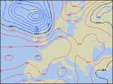
On Thursday, westerly winds will be very light everywhere, so in any sunny spells it will feel pleasant. However, sunshine will be in short supply, as weather fronts trundle slowly eastwards across the UK. These will give cloud and outbreaks of showery rain, especially to England, Wales and Scotland during the day. The best chance of seeing any sunshine will be across south-east England and first, and also across Ireland and Northern Ireland during the afternoon. A weak ridge of high pressure is expected on Friday, allowing much of the UK to start dry with some sunshine. For England, Wales and eastern Scotland, the fine weather should stay put into the afternoon, and with light winds it'll feel quite warm. However, thickening cloud out to the west will threaten rain across western parts of Ireland and Northern Ireland during the afternoon, reaching western Scotland by evening. South-westerly winds will become strong here later.
 Saturday 04/09/04 Sunday 05/09/04
Some very warm weather is expected in southern England at first on Saturday, but this will be very short-lived. Elsewhere, fresh to strong south-westerly winds will drive cloud and rain eastwards across all parts, reaching eastern England by tea-time. Some of this rain will be heavy at times, but it will clear to a mixture of sunny spells and blustery showers across Ireland and western parts of the mainland UK during the afternoon and evening. It does indeed look as if southern parts of the country are in for something a little more summery on Sunday, despite the start of September signalling the run-up to Autumn. High pressure will give predominantly dry conditions across much of England and Wales, together with some warm sunshine. There is the risk of a few sharp showers, but these will be well-scattered. A different story for Northern Ireland and Scotland, as weather fronts continue to give more cloud and the risk of showery rain. Windy here too.
 Monday 06/09/04 Tuesday 07/09/04
Monday is currently looking very promising for southern parts of England and Wales, as high pressure across Northern France continues to keep conditions fine and settled. With plenty of sunshine, it will become increasingly warm here, and these conditions will extend to much of Ireland during the afternoon. However, weather fronts lying through Northern England, north Wales and Northern Ireland will give showery rain, much of it heavy with thunder. Scotland should be brighter, but still with plenty of showers. However, this rain is expected to be nudged northwards into Scotland on Tuesday, as the ridge of high pressure extends its warm, sunny weather across the rest of the UK. Wednesday will see similar conditions to Tuesday, although the end of the week looks set to become very unsettled with wind and rain in most places. As ever, please check back for further long-range forecast updates.