Long-range Outlook: 02/10/04 - 07/10/04
Windy and cool. Rain giving way to sunshine and showers.
Click here for details of the weather over the next few days.
Please note that forecasting beyond five days is notoriously difficult, and small errors at short-range can lead to large deviations further in time. Our longer-range forecasts are based on the most accurate weather data available at the time, but alterations may be required as the period progresses. Please check back regularly for the most up-to-date forecast run.
Saturday 02/10/04 to Sunday 03/10/04
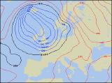
This weekend's weather will be living up to Autumn, with low pressure affecting much of the UK throughout. On Saturday, a deep area of low pressure will give strong to gale force winds across Northern Ireland and western Scotland, with outbreaks of heavy rain moving eastwards. This rain will also affect Ireland, eastern Scotland and northern England through the afternoon, but the rest of England and Wales will be mostly dry with a few sunny spells developing. More persistent rain will spread across many south-western parts of England, Wales and Ireland overnight though. This will result in a wet morning across most of England and Wales, with some heavy bursts of rain around. However, the rest of the UK and Ireland will be much brighter with a mixture of sunny spells and scattered blustery showers. This brighter weather will reach most of England and Wales through the afternoon, but everywhere will remain cool in brisk westerly winds.
 Monday 04/10/04 to Tuesday 05/10/04
Another deep area of low pressure is expected to move in from the west on Monday, continuing the unsettled run of weather. Heavy showers will break out widely across Ireland, Wales and western parts of England during the morning, and after a sunny start these will transfer to central and eastern England. There's the risk of hail and thunder in some of the showers, and it will be very gusty at times. The best of the sunshine, with fewest showers, will be across Scotland in the afternoon. On Tuesday, as the low pressure remains just to the west of Ireland, a spell of more persistent rain will sweep eastwards across most places during the day. Further sunshine and blustery showers will move in across Ireland, Northern Ireland and Wales during the afternoon, but Scotland together with most of England will remain rather wet for the rest of the day. Winds will remain fresh and westerly, keep temperatures at, or slightly below, average.
 Wednesday 06/10/04 to Thursday 07/10/04
Mid-week will bring little respite to the unsettled conditions, as low pressure produces another rash of showers across the UK and Ireland on Thursday. Few places will escape with a completely dry day, although there will be plenty of sunny spells around. The most frequent of the showers will be across Ireland, Northern Ireland, western Scotland and Wales, but they'll become increasingly thundery as they develop across England during the afternoon. The only subtle change in the weather on Thursday, is that winds will become more north-westerly across Ireland during the day, pulling in slightly cooler air here. Otherwise, it will be another day of sunny spells and frequent, prolonged showers, some heavy with the risk of hail and thunder. Remaining rather blustery throughout, and at present there looks little let-up in the unsettled conditions for the end of the week and the weekend. As ever, please check back for further forecast updates.