Long-range Outlook: 02/11/05 - 07/11/5
Rain at first. Drier Weekend.
Click here for details of the weather over the next few days.
Please note that forecasting beyond five days is notoriously difficult, and small errors at short-range can lead to large deviations further in time. Our longer-range forecasts are based on the most accurate weather data available at the time, but alterations may be required as the period progresses. Please check back regularly for the most up-to-date forecast run.
Wednesday 02/11/05 to Thursday 03/11/05
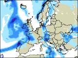
A huge area of low pressure is expected to sit to the west of Ireland during Wednesday, with high pressure over the North Sea. This will result in a southerly flow, so it will be very mild once again. In fact, the southerly winds will be fresh to strong across the UK and Ireland, with gales through the Irish Sea. Eastern Scotland and northern England may have a locally chilly start to the day though, but there will be some sunshine. However, heavy and persistent rain across Ireland during the morning, will spread to all but north-east Scotland through the afternoon. On Thursday, the low will edge a little closer to the UK, and there is the potential for severe gales around the coasts of the Irish Republic, Wales and south-west England. South-westerly winds will also remain strong across the rest of the UK, with coastal gales. Heavy rain will spread across all areas during the morning, clearing to sunshine and blustery showers in the afternoon. The heaviest and most frequent showers will be across Ireland and western coasts of the UK, perhaps with hail and thunder. Becoming cooler.
 Friday 04/11/05 to Saturday 05/11/05
We're expecting the beginnings of a change during Friday, as our deep area of low pressure moves away north-eastwards, allowing high pressure to build in from the southwest. However, most places will have a cloudy day, with showers or longer spells of rain. The rain will be most persistent in eastern England and eastern Scotland, whilst brighter weather edges into southern Ireland and the south-west of England by evening. Friday night will become drier across most places, and with the winds falling light, it could turn rather foggy. Saturday's firework and bonfire celebrations could well be on to a winner, as it's looking like high pressure will be in control of the weather across most places. It will be mainly dry during the daytime, although there will be a fair amount of cloud around. As evening approaches, and many of you will be taking to the outdoors for the firework festivities, things are looking pretty good. It will be mainly dry everywhere, and with light winds, it could turn quite misty and foggy towards midnight. It shouldn't be too chilly though, despite some clear periods. The only exception could be north-east England and eastern Scotland, where cloud could be thick enough for drizzle.
 Sunday 06/11/05 to Monday 07/11/05
It'll be a murky start to Sunday morning across the UK and Ireland, with the mixture of mist, fog and the remnants of Saturday night's bonfire smoke. However, as the morning progresses, a south-easterly breeze will pick up, and this should disperse the mist and fog quite readily by noon. Thereafter, most of the UK and Ireland will be dry with some sunny spells, although eastern coasts could remain rather grey. Towards evening, rain will arrive in western parts of Ireland. Monday should remain dry across England and Wales, with occasional sunshine, but also a lot of cloud. More unsettled across Ireland, Northern Ireland and Scotland, with freshening winds and outbreaks of rain. As ever, please check back for further forecast updates.