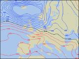
Long-range Outlook: 01/01/05 - 06/01/05
Changeable. Mild one minute, cold the next!
Click here for details of the weather over the next few days.
Please note that forecasting beyond five days is notoriously difficult, and small errors at short-range can lead to large deviations further in time. Our longer-range forecasts are based on the most accurate weather data available at the time, but alterations may be required as the period progresses. Please check back regularly for the most up-to-date forecast run.
Saturday 01/01/05 to Sunday 02/01/05
Eastern parts of England will have a bright start to the new year, but this won't last long. During Saturday morning, heavy rain will be sweeping into much of Scotland, Northern Ireland and northern England, turning to snow over the Scottish mountains later. Occasional rain will also work eastwards across Ireland, Wales and western parts of England during the day, reaching eastern England by evening. On Sunday, northern parts of the UK will be much brighter, but also much colder. Showers will fall as snow over the high ground of Scotland, northern England and northern Ireland, perhaps even to lower levels for a time. Showers will also affect north Wales, and possibly the Midlands too, although most of these will be as rain. Elsewhere, it should become mostly dry with some sunny spells, especially across sheltered eastern parts of both Ireland and England.
 Monday 03/01/05 to Tuesday 04/01/05
On Monday, any remaining showers in eastern Scotland will die away before dawn. The rest of the UK will have a sunny morning, but with frost and fog slow to clear in some parts. Across Ireland and Northern Ireland, thickening cloud will bring rain to most places by early afternoon, and this rain will spread to western Scotland, north-west England and Wales before evening. Staying dry and bright in the east and south, although sunshine will become increasingly hazy. On Tuesday, milder air will have returned to most of the UK. However, there will be a good deal of cloud, especially around western coasts where drizzle will return. The best of any brightness will be to the east of high ground. Northern Ireland and north-west Scotland will have more persistent rain, turning heavier through the afternoon. Rather windy everywhere, with strong gusts across eastern England.
 Wednesday 05/01/05 to Thursday 06/01/05
Weather fronts will clear away from eastern England and eastern Scotland on Wednesday morning, as a ridge of high pressure builds across the UK. This will give many places a dry day with some bright or sunny spells, and with lighter winds it will feel pleasant. However, conditions will deteriorate across Northern Ireland, western Ireland and western parts of Scotland in the afternoon, as strengthening south-westerly winds throw outbreaks of rain in off the Atlantic during the afternoon. Very unsettled everywhere on Thursday, as bands of rain are followed by showers from the west. Winds will become strong at times, and there is a risk of gales around exposed parts of Scotland and Northern Ireland. The best of any afternoon sunny spells will be across south-east England.