Weekly Outlook : 02/02/05-07/02/05
Turning more unsettled. Wintry next week.
Wednesday 02/02/05 to Thursday 03/02/05
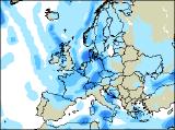
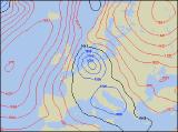
The settled, almost stagnent weather situation is set to continue during Wednesday, with a vast area of high pressure to the west of Ireland. Winds will remain in a north to north-westerly direction, dragging in mild air from the Atlantic. Skies will be mostly cloudy, with the risk of light rain and drizzle. This is most likely across eastern and northern England, together with Scotland. Some sunny spells will develop, especially in southern Ireland, Wales and south-west England. Subtle change still look like arriving during Thursday, as a stronger north-westerly wind develops across Northern Ireland and Scotland. This will bring in thicker cloud, with more persistent outbreaks of rain and drizzle through the afternoon. However, the rest of the UK and Ireland will remain under the influence of high pressure, thus staying mainly dry but rather cloudy.
 Friday 04/02/05 to Saturday 05/02/05
Expect big changes everywhere on Friday, as a spell of wet weather sweeps south-eastwards across the UK and Ireland. This will have cleared southern England by early afternoon, leaving behind some sunny spells. However, more cloud and rain will be spreading into Scotland and Northern Ireland, some heavy with the risk of snow over the mountains and it turns colder. Perhaps the driest, brightest weather will be across parts of southern Ireland and south-west England. Winds are expected to turn northerly on Saturday, and it looks as if much of the UK will have a return to winter. Much colder air will sweep southwards, although there will be some decent spells of sunshine. Showers will affect many eastern coasts of both England and Scotland, these turning increasingly to hail, sleet and snow through the day. Western parts of the UK mainland will be dry and bright, as will Ireland. However, western Scotland and Northern Ireland will be cloudier with rain or sleet.
 Sunday 06/02/05 to Monday 07/02/05
Confidence for the rest of the forecast is very low indeed. Current indications suggest that a cyclonic east or north-easterly will develop, and this could potentially result in some very wintry weather. On Sunday, frequent sleet and snow showers are expected to affect much of central and eastern England, perhaps giving a covering in places. Western parts of England and Wales should stay dry and bright. Scotland and Ireland will be rather cloudy with rain, turning to snow in the north. The start of next week is looking similar, with cold easterly winds bringing the risk of snow to many areas. However, as mentioned the confidence on this scenario is low at present, so please check back for further, more detailed outlooks for next week's weather.