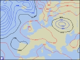
Long-range Outlook: 03/02/06 - 08/02/06
Dry Weekend. Snow Risk Next Week?
Click here for details of the weather over the next few days.
Please note that forecasting beyond five days is notoriously difficult, and small errors at short-range can lead to large deviations further in time. Our longer-range forecasts are based on the most accurate weather data available at the time, but alterations may be required as the period progresses. Please check back regularly for the most up-to-date forecast run.
Friday 03/02/06 to Saturday 04/02/06
With some parts of the UK crying out for rain, Friday's forecast will see a continuation of dry conditions, as high pressure dominates the weather across the UK and Ireland. There will be some morning fog and frost to clear, but thereafter much of England, Wales and the Irish Republic will be dry with sunshine. There will be more cloud across Scotland and Northern Ireland, perhaps with drizzle across the extreme north. However, even here, most places will stay dry. Winds will be generally light across all areas. The high pressure will still be firmly in charge during Saturday, so the day's weather will effectively be a re-run of Friday's. Morning frost and fog will clear once again to leave a dry day with varying amounts of cloud and some sunny spells. Once again, the most extensive cloud will be across northern Scotland, perhaps drifting down the East Coast into Northeast England during the day. Light winds for the most part, although a little breezy in the Northwest.
 Sunday 05/02/06 to Monday 06/02/06
Those who enjoy dry conditions will be pleased to hear that Sunday will maintain the conditions seen for quite some time now, with dry and sunny weather across large parts of the UK. Those who want to see active weather conditions will have to wait even longer! The frost will be quite extensive across much of the UK first thing, but it will stay fine. Ireland and Northern Ireland will only have a patchy frost though, as gentle southerly winds blow in a lot of low cloud. Model output is suggesting that some areas may finally be in for a change on Monday, as our resident area of high pressure slips southwards. It will still dominate the weather across England, Wales and the Irish Republic though, spelling out another dry day with some sunshine. For Scotland and Northern Ireland, freshening northwesterly winds and Atlantic weather fronts will give overcast skies and outbreaks of rain, heavy at times. The rain will turn to snow over northern mountains later too, as winds increase to gale force.
 Tuesday 07/02/06 to Wednesday 08/02/06
Confidence in the forecast reduces markedly by Tuesday, although model output has been quite consistent with bringing in a sweeping change. Monday's rain across northern areas is expected to blast southwards across all parts on Tuesday, turning wintry over the high ground on its back edge. Behind the rain, there will be a rash of heavy showers across Scotland, northern England and Northern Ireland. These will be of rain at first, but as strong to gale force winds set in later, these will turn increasingly to hail, sleet and snow. Winter fans should not get too excited just yet, but output is suggesting a seriously wintry blast on Wednesday, as gale force northerly winds sweep in from the Arctic. There will be some sunny spells across sheltered southern and eastern areas, but elsewhere, heavy snow showers will become widespread. Across Scotland, Irish Sea coasts, and North Sea coasts, local blizzard conditions are possible with an appreciable snowfall in places. Stay tuned to further forecast updates for more details on this potentially wintry spell of weather.