Long-range Outlook: 03/07/04 - 08/07/04
Rain, showers, and then more rain! No sign of summer!
Click here for details of the weather over the next few days.
Please note that forecasting beyond five days is notoriously difficult, and small errors at short-range can lead to large deviations further in time. Our longer-range forecasts are based on the most accurate weather data available at the time, but alterations may be required as the period progresses. Please check back regularly for the most up-to-date forecast run.
Saturday 03/07/04 to Sunday 04/07/04
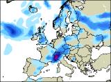
The unsettled weather will continue on Saturday, with brisk westerly winds becoming north-westerly through the day. Most places will see some sunny spells, but at the same time there will be a rash of heavy showers developing, especially across northern and western parts where there will be the risk of thunder. Later in the afternoon, more substantial rain will move into parts of southern Ireland and south-west England. Temperatures will be around average or a little below everywhere. The north-westerly winds will continue to give a mixture of sunshine and blustery showers across much of Ireland, Scotland and northern England on Sunday. However, thicker cloud across the rest of England and Wales will give more prolonged, heavy, and in places thundery rain, with the risk of local flooding in southern counties of England. Not surprisingly it will feel rather cool everywhere, although the winds will fall light across many central and southern areas.
 Monday 05/07/04 to Tuesday 06/07/04
On Monday, the heavy rain will be slow to clear away from south-east England, and may linger for much of the afternoon. Elsewhere, it will be a return to the familiar story of sunshine and showers. Some of the showers will be heavy with hail and thunder, particularly across Northern Ireland and western Scotland. Disappointingly cool everywhere in a brisk north-westerly wind; certainly feeling decidedly Autumnal! Low pressure will still be lurking to the north of the UK on Tuesday, giving a west to north-westerly flow. However, the winds should become lighter, so in the sunny spells it will feel fairly pleasant out and about. However, the showers won't take long to get going once again, some heavy and thundery, although south-western parts will become mostly dry and bright during the afternoon.
 Wednesday 07/07/04 to Thursday 08/07/04
On Wednesday, another band of rain, heavy at times, will sweep in from the west during the day. Starting across much of Ireland during the morning, it will spread eastwards across Scotland, northern England and Wales during the afternoon. Central and southern England will stay mostly dry with some sunshine, although this will become increasingly hazy in the afternoon. Westerly winds will remain largely light, although freshening in the north later. Staying unsettled into Thursday, with absolutely no sign of any summer weather returning. Low pressure both to the north and the west will give some heavy, prolonged showers right across the UK, with hail and thunder likely once again.