UK white Xmas update
Higher grounds might do
 This Christmas outlook is based on the latest ensemble runs of the GFS, GME, UKMO, ECMWF and GEM models. More here
General situation: It seems as if our Christmas weather will be mainly controlled by a relatively stationary low east of Iceland interacting with a relatively stable high-pressure system across the NE Atlantic. This is causing a pattern known as a north-westerly situation which translates into unsettled and relatively mild and wet weather.
Most of the standard numerical models are reproducing this pattern since last Friday and thus confidence in this forecast is increasing a tiny bit with every new model run. Although there is still a long way to go we suggest a confidence level of 60% at this point and chances for a snow-laden northeasterly pattern are decreasing.
Confidence is moderate that unsettled and colder weather will start to dominate the northern UK by mid-week and Friday might see snow showers for much of the nortwestern UK and N Scotland. After another mild interlude new wintry showers will be hitting the UK next Monday and some of this snow might survive at sheltered places on higher ground until Christmas.
Christmas Eve: confidence is moderate to low that there will be no snow lying, beside some left-over drift in gullies on very high grounds. A passing warm front will bring some mild, dull and windy weather for many. If the pattern persists this air-mass will have travelled thousands of miles across warm Atlantic waters and will hardly be cold enough to produce any snow whatsoever.
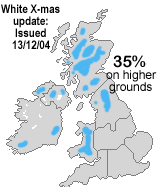
Christmas Day: The good news. With the incoming cold front pushing south-east chances for snow showers and snow are substantially increasing for all areas above 300m to 500m (1,000ft to 1,500ft), but not for lower ground.
Issued Monday, 13th Dec, 3:00 pm. Updated regularly.