UK white Xmas update
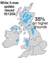
Wintry showers on higher grounds
 This Christmas outlook is based on the latest ensemble runs of the GFS, GME, UKMO, ECMWF and GEM models. More here
General situation: It seems as if our Christmas weather will be mainly controlled by a relatively stationary low pressure between Iceland and W Scandinavia interacting with a relatively stable high-pressure system across the NE Atlantic. This is causing a pattern known as north-westerly situation which translates into unsettled and a mix of mild sometimes cool and wet weather.
Most of the standard numerical models are reproducing this pattern since last week and thus confidence in this forecast is increasing a tiny bit with every new model run. Although there is still a long way to go we suggest a confidence level of 60% at this point.
Confidence is moderate to good that the unsettled weekend and beginning of next week will produce enough snow on higher ground above 700 m asl to survive the following mild spell. All others will see a mix between mild and cool and breezy weather with wintry showers on higher ground. This turning gradually cooler towards 24th and 25th.
Christmas Eve: confidence is moderate that there will be no snow lying, beside some left-over drift in gullies on very high grounds above 700 or 800m asl. It's going to be relatively wet especially on western flanks from the Highlands down to the Cambrian Mountains.
Christmas Day: Not much of a change. It's slightly too cool for the classic thawing around Christmas, but the Polar Front is still too far north to make it a white Christmas for most of us. Chances for higher grounds are still pretty good.
Issued Monday, 16th Dec, 1:30 pm. Updated regularly.