British Isles White Christmas Forecast
TOI - December 11th 2002
 The best we can say is that confidence for this forecast is still low (!) and that the situation might still change completely. At the moment it's a greenest case scenario. The weekend prior to Christmas will see some mild maritime air entering the British Isles from southwest.
The associated low pressure systems seem to be able to push the high pressure across Scandinavia and Central Eastern Europe further east. So maybe some snow or wintry showers over the east turning rainy, and if there is any lying snow it will be melted away.
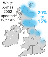
Following this, however, the latest model runs reveal high pressure to build up northwest of the British Isles. While this is mild news (with overnight frost maybe) for western and southern parts of the British Isles, there might be some trough lines hovering southward across the east in a wet cold northerly flow.
So maybe some snow or wintry showers on northern slopes of higher grounds across the north and northeast. Especially after dark between 24th and Christmas Day. Otherwise rather mild then wintry.